Live · 3,222 counties
Commercial real estate intelligence, structured for the credit memo.
Built for
Investment sponsors
MMCG Analytics is the data platform written by the feasibility consultants who author the studies lenders approve. Parcel and ownership, building footprints, flood and hazard exposure, traffic counts, demographics, competitive supply and the SBA lending record, resolved at one address and assembled in the form a credit committee expects to read.
Parcels loaded from county records
Counties with demographic coverage
Traffic count records, 51 jurisdictions
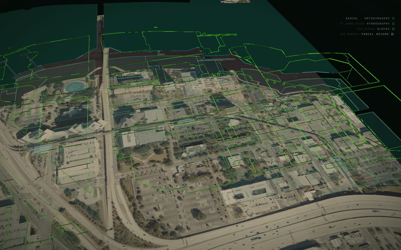
The platform, on a real site
A site, its comparables, and the evidence between them.
The layer stack assembles, collapses into one fabric, and the city stands up around a real Jacksonville parcel. Every figure on screen traces to a record.
Poster frame paints first. The scene mounts on interaction or on entering the viewport and scrubs to this section's own scroll range. Reduced motion keeps the still.
The platform in numbers
Coverage and discipline measured the way credit committees measure them.
US parcels loaded from county records, tied to ownership and assessment where disclosed.
Counties with demographic coverage, which is every county in the country.
State DOT traffic count records across 51 jurisdictions, at count year 2024.
Commercial asset classes with calibrated comparable sets and absorption frameworks.
Business days from query to a signed feasibility study, when escalated to MMCG Invest.
Coverage current through Q2 2026. Data lineage and source attribution are published in the methodology appendix.
The platform
From the address up. Eight modules, one underwriting language.
Enter an address. Receive parcel, building, zoning, demographics, competitive supply, location risk, traffic and coverage-grade underwriting. Every output is sourced, normalised and citable in the form a credit memo expects. Where a layer is not held for a market the module says so rather than returning a confident blank.
Parcel and site
Address-level lookup across the parcel corpus: boundary, APN, lot dimensions, assessed value, recorded sales, and ownership of record where public records disclose it.
86M+ parcelsBuilding footprints
Structure footprints and centroids at national scale, tied to the parcel beneath them. Attribute depth varies by market and the module states which it has.
National coverageZoning
Base district and overlay normalised to a comparable classification, with the source jurisdiction and effective date on every record. Statutory frameworks are held today.
In buildDemographics
Census ACS, decennial and BLS across every county in the country, with the trade area indexed against county, metro and state rather than reported bare.
3,222 countiesCompetitive supply
Establishment counts by NAICS industry inside the trade area, which is the honest read on how many of a thing already operate near a site and where the room is.
By NAICSLocation risk
FEMA flood, USGS seismic, wind, wildfire, hail and climate exposure, scored as seven independent vectors and composited into one index with each input named.
7 vectorsTraffic and access
State DOT annual average daily traffic resolved at the address, with count year carried, so throughput is read on the corridor beside the site rather than estimated.
10.6M recordsLending and DSCR
The SBA 7(a) and 504 loan record by county, industry, lender and status, plus coverage tested at the SOP 50 10 8 floor and the stricter USDA definition.
SBA tapeCoverage
What data does MMCG Analytics hold, dataset by dataset.
Most platforms describe their coverage in adjectives. This is the register, with the source named and the period stated on every line, because a number without a vintage is not evidence and a credit committee will treat it accordingly.
| Dataset | Coverage | Source | Period |
|---|---|---|---|
| Parcel boundaries and ownership | 86M+ records | County property records | Rolling |
| Demographics and households | 3,222 counties | Census ACS 5-year | 2020 to 2024 |
| Population components of change | 3,222 counties | Census population estimates | Vintage 2024 |
| Traffic counts, AADT | 51 jurisdictions | State departments of transportation | Count year 2024 |
| FEMA flood hazard | Florida 593,586 records, plus AZ, NC, TX, MO, WI | FEMA National Flood Hazard Layer | Current panels |
| Building footprints and centroids | National | Overture Maps | 2025 |
| Wetlands | National | US Fish and Wildlife NWI | Current |
| Wind design speed screening | Contiguous US | ASCE 7-22 | Current |
| Establishment counts by NAICS | 3,222 counties | County Business Patterns | Latest release |
| Labor force and unemployment | 3,222 counties | BLS LAUS | Monthly |
| County GDP and personal income | 3,222 counties | BEA CAINC | Annual |
| SBA 7(a) and 504 lending | National, by county and NAICS | SBA FOIA release | Through 2026 |
| Radon zone | 3,138 counties | EPA | Current |
| Zoning district and overlay | In build | 460+ jurisdictions per state | Pending |
Where a layer is not held, the platform says so
Coverage inside a state is uneven, and it matters which kind of gap you are looking at. A county with no mapped flood panel and a county with no flood risk are entirely different statements, and conflating them is how a screening tool becomes a liability. Every module reports its own coverage for the geography you asked about rather than returning a confident blank, and a layer still in build is labelled in build wherever it appears.
How it works
How to research a commercial property, in four steps.
The sequence below is the same one MMCG Invest follows when it opens a feasibility engagement. The platform exists because those first two steps used to take an analyst several days and a stack of subscriptions.
Enter the address
Any address in the contiguous United States. The platform geocodes it and resolves the parcel beneath it, which is the unit every other layer attaches to. No account, no cost.
Read the layers
Flood zone, wetlands, traffic on the adjacent corridor, demographics of the trade area, establishment counts showing what already operates nearby, and the lending record for that county. Each with its source and period.
Build the workspace
Set the trade area, compare comparable sites, test coverage against the SBA floor, and save the session. This is where a screening becomes an analysis you can defend to someone else.
Escalate if it is real
Any session can be promoted to a signed feasibility study authored by MMCG Invest, using the evidence you already assembled. That is why the turnaround runs in days rather than weeks.
What this replaces, and what it does not
It replaces the first week of a site investigation: the assembling, the tab-switching between a county appraiser, a FEMA viewer, a DOT map and a census table, and the reconciling of four different vintages into one picture. It does not replace the county property appraiser as the authoritative record of ownership and assessment, it does not replace a licensed appraisal, and it does not replace the judgement of someone who has underwritten this asset class before. It gets you to the point where that judgement has something to work with.
Address lookup
What comes back from a single address.
The platform geocodes the address, resolves the parcel beneath it, and returns the trade area around it. Below is the shape of a real return, from a boutique hotel site in Bentonville, Arkansas.
Parcel · site
- Lot area1.21 ac, 52,708 sf
- Assessed value$2,855,000, FY26
- Last recorded sale$3.48M, Aug 2023
- Existing GBA18,000 sf, 1970 vintage
- Base zoningIn build
- Ownership of recordIn workspace
Demographics · competition
- Tract population5,476
- Median household income$87,064
- Bachelor's degree or higher51.0%
- Median age36.6
- Median gross rent$966
- Establishments in radiusBy NAICS
Risk · underwriting
- Composite risk27 / 100, low
- FEMA floodZone X, outside SFHA
- Seismic, ASCE 7SDC C, 0.163g
- Wind34 / 100
- Wildfire14 / 100
- Stabilized DSCR1.40x
Reading a parcel record without misreading it
Assessed value is not market value, and the gap between them varies by state, by county and by how recently the roll was updated. A last sale price carries no indication of whether it was arm's length. Lot area from a tax roll and lot area from a survey disagree more often than people expect. None of this makes the record less useful, but a screening tool that presents assessment as valuation is teaching a bad habit, so every field here is labelled as what it is and sourced to where it came from.
Ownership of record resolves inside the workspace rather than on a public page. Fields marked in build are not displayed until the layer lands.
Location risk
The hazards a credit committee will price. Quantified, sourced, defensible.
Seven independent risk vectors are scored against authoritative federal datasets, then composited into a single index weighted to the factors that actually drive insurability and reserve treatment. FEMA flood, USGS seismic and climate resolve at the parcel; wind, hail and wildfire are regionally modelled and labelled as such.
Low risk · tier A
A composite blends live federal reads with regionally modelled vectors. Every input keeps its own score and its own label, so a committee can see which part of the number is measured and which is modelled.
- FEMA floodResolved at the parcel
- USGS seismicASCE 7 design category
- WindASCE 7-22 design speed
- WildfireUSFS hazard potential
- Hail and tornadoNOAA storm history
- Climate heatDays at or above 90F
- WetlandsNational inventory
Who uses it
The platform takes three different shapes, depending on who is reading it.
For lenders and CDCs
Pre-screen the deal before the file lands on your desk.
Underwriting officers validate a sponsor narrative in minutes: comparable set integrity, demand depth, supply pipeline, and coverage sensitivity at the SBA SOP 50 10 8 floor.
- Sponsor feasibility studies cross-checked in place
- SBA and USDA loan tape benchmarked by lender pair
- Flood, wind and seismic exposure resolved at the parcel
For sponsors and developers
Pre-underwrite your project the way your lender will.
Test feasibility before retaining counsel, a contractor or a consultant. The platform models the questions a credit committee will ask, so the answers exist before the file does.
- Site selection across demographic and regulatory overlays
- Competitive supply from establishment counts, not guesswork
- One click escalation to a full MMCG feasibility study
For brokers and investors
Source, position and defend the price the buyer's lender will respect.
Investment sales teams position assets, calibrate broker opinions of value, and assemble the lender-grade evidence packet that turns a soft letter of intent into a closed transaction.
- Comparable depth filtered to the buyer's lending universe
- Cap rate spread by submarket and asset class
- Exhibits with citation provenance as delivered
The flagship reading
The MMCG SBA DSCR Index.
A quarterly composite reading of debt service coverage compression and expansion across the SBA 7(a) and 504 loan tape, segmented by asset class and lender pair. The index tracks the SOP 50 10 8 transition and is built from public SBA FOIA data, normalised to the methodology MMCG applies in its feasibility studies.
Current reading, blended portfolio
Quarter over quarter movement
Loans in the underlying tape
MMCG SBA DSCR Index Live
Quarterly · segmented by asset class and lender pair
Coverage holding above the SOP floor.
Quarter over quarter +0.06x
Coverage by state
Every county has a page. Start with your market.
State and county pages carry what is held locally: the corridors and their traffic counts, flood panel status resolved per county, the demographic and migration profile, establishment counts showing competitive supply, and the SBA lending record by industry. The workspace runs on every one of them.
Why county-level rather than metro-level
Metro boundaries are useful for comparing economies and useless for underwriting a site. Permitting, zoning, impact fees, flood mapping, property assessment and the reviewing authority are all county or municipal functions, and they change at the line. Two parcels four miles apart in the same metro can face different codes, different fee schedules and different reviewers. County is the smallest geography where the regulatory picture is stable enough to describe and large enough to have published data behind it, which is why the coverage is built that way.
Feasibility studies
When a lookup needs to become a document a lender will accept.
MMCG Invest, LLC has spent years producing the lender-facing feasibility study: signed by the firm, relied on by SBA and USDA lenders and by banks, and built on the same comparable sets, demographic reads and coverage sensitivities that surface in this workspace.
Any workspace session can be escalated. The data you have already assembled becomes the evidence base, which is why the turnaround is measured in days rather than weeks. Studies are delivered in the structures lenders require: SBA SOP 50 10 8, USDA 7 CFR Part 5001 Appendix A, and conventional credit committee templates.
These are feasibility studies and market analyses, not appraisals. The distinction matters to a credit file and it is stated on every deliverable.
When a lender actually requires one
SBA SOP 50 10 8 requires an independent feasibility study for certain start-up and special purpose properties, and lenders frequently require one beyond the mandatory cases where a project carries construction risk, an untested revenue model or a market the borrower has not operated in. USDA runs its own requirement under 7 CFR Part 5001. The requirement is federal and does not vary by state; the market analysis inside the study very much does.
Feasibility studies →The escalation path
- Run the addressFree
- Build the workspacePaid tier
- Promote to a studyEngagement
- Typical turnaround9 to 16 days
- Asset classes covered30+
- Delivered underSOP 50 10 8
The methodology
Four pillars. USPAP-grade discipline.
Every dataset, every model and every visualisation on the platform is governed by the same analytical framework MMCG applies in its third-party feasibility studies. Coverage is documented, sources are attributed, and reproducibility is a contractual standard rather than an aspiration.
Sourced
Every record traces to an enumerated primary source: county property appraiser, state DOT, FEMA, the SBA tape, Census ACS, BLS, or MMCG's own research. Lineage is queryable on every cell.
Normalized
Comparables are reconciled to subject characteristics before they reach the screen. Asset class, vintage, market position and revenue model are matched on a calibrated weighting the firm publishes and stands behind.
Reproducible
Every workspace state can be replayed. Datasets carry timestamped versions and model outputs carry their assumption set. A study delivered today produces the same numbers six months from now.
Lender-ready
Outputs map to the structures lenders require: SBA SOP 50 10 8, USDA 7 CFR Part 5001 Appendix A, and conventional credit committee templates. Exhibits are citation-ready as delivered.
The platform is governed by the same USPAP-aligned standards under which MMCG Invest authors its bankable feasibility studies. Every dataset carries its source and the period it describes, and a figure that cannot be traced does not appear.
Read the appendix →Common questions
What this is, and what it is not.
What is MMCG Analytics?
The commercial real estate data platform built by MMCG Invest, LLC, the feasibility consulting practice whose studies SBA lenders, USDA lenders and banks rely on. Enter an address and the platform returns parcel, building, flood, wetland, traffic, demographic, competitive supply and lending layers in the structure a credit memo expects.
It is not a listing portal and it is not an appraisal tool. It is the underwriting data layer, opened up so you can run it yourself rather than waiting on an analyst.
Is it free to use?
Address lookup is free and runs without an account. Deeper layers, saved workspaces, comparable exports and API access sit on the paid tiers, and the escalation path to a signed feasibility study is a separate engagement with MMCG Invest.
Where does the data come from?
County property records, state departments of transportation, FEMA, USGS, NOAA, Census ACS and the decennial census, BLS, the SBA FOIA loan release, and MMCG's own primary research. Every field carries the source it came from and the period it describes.
Where a layer is not held for a given county, the platform says so rather than filling the gap with a state average. An unmapped county and a county with no risk are different statements and are never conflated.
Is this an appraisal?
No. MMCG Invest produces feasibility studies and market analyses. Those are distinct engagements from an appraisal, they answer different questions, and they are relied on differently by lenders. The methodology is USPAP-aligned and the distinction is stated on every deliverable.
Can a lookup become a feasibility study?
Yes, and that path is the reason the platform exists in this shape. Any workspace session can be promoted to a full study authored and signed by MMCG Invest, delivered in the structures lenders require and typically inside nine to sixteen business days from a complete brief.
Which states does MMCG Analytics cover?
Demographic, economic and lending layers cover all 3,222 counties in the country. Parcel, flood and traffic coverage varies by state, and rather than publish a single coverage claim that is true in some places and misleading in others, each module reports its own coverage for the geography you asked about.
State and county pages exist for the ten largest states by population, and every county in those states has its own page carrying what is held locally.
How current is the data?
Every field carries the period it describes rather than the date it was retrieved, which are different things and only one of them is useful. Traffic counts sit at count year 2024, demographics at the ACS 2020 to 2024 five-year estimates, flood at current published panels, and the SBA lending record runs through 2026.
Statutory content is pinned to a specific edition and the pin is re-verified against the newest available edition rather than assumed still current. That practice is what surfaced the repeal of Florida's commercial rent tax, a change most published Florida market analysis still has not caught up with.
Do I need an account to look up an address?
No. Address lookup runs without an account and without cost, because a tool you have to register for to evaluate is a tool most people never evaluate.
An account is needed once you want to save a workspace, export comparable sets, or reach the API.
How is this different from LoopNet, Crexi or CoStar?
Those platforms answer what is for sale, what it sold for, and who brokered it. They are transaction infrastructure and they are good at that job.
This answers a different question: whether a site works. What is the flood exposure, what is the traffic on the corridor beside it, how many of this business type already operate in the trade area, has a lender financed one here recently, and what does coverage look like at the SBA floor. That question applies to parcels that are not for sale and have no listing, which is most of them, and it is the question a feasibility study exists to answer.
What is DSCR and why does the platform show it?
Debt service coverage ratio measures how far a property's net operating income exceeds its debt service. It is the single number a credit committee reaches for first, because it answers whether the project services its own debt with room to spare.
SBA SOP 50 10 8 sets a floor that lenders underwrite against, and USDA applies its own stricter definition. Showing coverage sensitivity at those thresholds rather than at a generic benchmark is the difference between knowing a deal pencils and knowing it is financeable, which are not the same thing.
Can I export the data or reach it through an API?
Yes, on the paid tiers. Exports carry the source and the period on every field, so provenance survives into your own spreadsheet rather than stopping at the screen.
That matters more than it sounds. A number pasted into a model without its vintage becomes an assumption nobody can check six months later, which is how stale figures end up inside credit files.
Who is MMCG Invest?
MMCG Invest, LLC is the commercial real estate feasibility consulting practice that built and operates this platform. Its studies are signed by the firm and relied on by SBA lenders, USDA lenders and banks.
That matters here because the platform is not a data vendor's product with a consulting arm bolted on. It is the internal infrastructure of a working feasibility practice, opened up, which is why it is organised around what a credit committee asks rather than what a listing portal shows.
Start here
Run your first address in the next five minutes.
Address lookup is free and needs no account. An account saves workspaces, exports and API access.
or tell us what you are underwriting
Talk to us
Tell us what you are trying to underwrite.
Lenders, sponsors and brokers: describe the file and we will come back within one business day with the coverage we hold for that market and the shortest path to the answer you need.
Indices and field notes
Delivered the morning of release.
The MMCG SBA DSCR Index, the cap rate spread reading and methodology updates, segmented by role.